
인공지능
AI가 토네이도 이후 재난 복구를 혁신하는 방법

 Securities.io를 Google의 선호 소스에 추가

AI가 자연 재해 복구를 개선하는 방법
자연재해가 발생하면 가장 시급한 과제는 지역 주민을 구조하고, 특히 전력·식수·의료 같은 기반시설을 정상적으로 복구하는 것입니다.
자연 재해가 발생하면, 즉각적인 필요는 지역 주민을 구하고 전력, 식수, 의료 등 인프라를 기능적인 상태로 복구하는 것입니다.
이는 기후 변화와 인구 증가로 인해 지난 10년 동안 이러한 사건에 대한 비용이 지속적으로 증가하면서 점점 더 큰 문제로 부각되고 있습니다.

출처: Spire
하지만 지역 사회의 실제 복구는 훨씬 더 오랜 시간이 걸리며, 피해 평가와 재건에는 수개월, 경우에 따라서는 수년이 필요합니다.
그러나 파악하고 정확히 평가해야 할 문제가 압도적으로 많아 대응이 지연되는 경우가 잦습니다. 보험사, 응급 서비스 기관, 기타 관계자의 인력이 부족하면 건물 하나하나를 점검하는 데도 많은 시간이 걸립니다.
“수동 현장 검사는 노동 집약적이며 시간이 많이 소요되어, 중요한 대응 노력을 지연시키는 경우가 많습니다.”
Abdullah Braik – 텍사스 A&M 대학 토목공학 박사과정 학생
이제 AI 기술로 상황이 달라질 수 있습니다. 텍사스 A&M 대학교 연구진 두 명은 원격 감지, 딥러닝, 복구 모델을 결합해 토네이도 피해 평가와 복구 전망을 한 시간 이내에 정확히 산출하는 AI 시스템을 개발했습니다.
이 방법은 복구 작업을 더 효과적으로 조직하는 데 도움이 될 수 있으며, 연구 결과는 Sustainable Cities and Society에 「원격 감지, 딥러닝 및 복구 모델을 통합한 토네이도 이후 건물 피해 자동 평가와 복구 예측」이라는 제목으로 게재되었습니다.
“우리 방법은 고해상도 감지 영상을 활용하고 딥러닝 알고리즘을 적용해 몇 시간 안에 피해 평가를 생성함으로써, 최초 대응자와 정책 입안자에게 즉시 실행 가능한 정보를 제공합니다.”
Abdullah Braik – 텍사스 A&M 대학 토목공학 박사과정 학생
토네이도 파괴: 미국에서 증가하는 위협
자연은 때로 사람과 그들이 사는 도시를 파괴할 정도로 위력적입니다. 대표적인 사례가 토네이도로, 미국의 이른바 토네이도 앨리를 비롯한 세계 여러 지역에서 비교적 자주 발생합니다.

예를 들어, 2011년 봄에 미주리주 조플린은 EF5 토네이도로 인해 풍속이 200mph(321km/h)를 초과하는 것으로 추정되는 폭풍에 휩쓸렸습니다. 이 폭풍은 161명을 사망하게 하고 1,000명 이상이 부상했으며 약 8,000가구와 사업체가 손상·파괴되었습니다. 토네이도는 인구가 밀집된 남중부 지역을 마일 폭으로 가로질러 파편이 된 잔해를 남기고 20억 달러 이상의 피해를 남겼습니다.
이번 달에도 치명적인 토네이도가 중서부와 남부 지역의 많은 주택을 파괴하고 큰 피해를 입혔습니다.
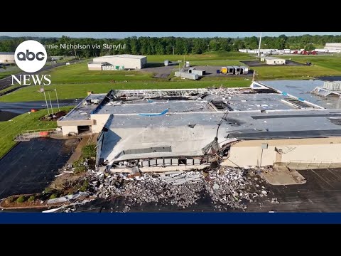
이 토네이도들이 초래한 피해의 전체 규모를 파악하려면 상당한 시간이 걸릴 가능성이 큽니다. 텍사스 A&M 대학교 연구진은 바로 이 지점에서 도움을 줄 수 있다고 봅니다.
토네이도 이후 피해 평가의 과제
이런 재난이 발생하면 일반적으로 응급 대응 인력, 도시계획가, 보험 전문가가 현장에 투입되어 파괴 규모와 대응 방안을 평가합니다.
토네이도의 강풍과 바람에 휩쓸린 무거운 물체는 가장 견고한 건물조차 파괴할 수 있으므로 특히 그렇습니다.
“재난 이후 피해 조사는 일반적으로 시간과 노동력이 많이 들며, 즉각적이고 신속한 갱신보다 모델과 코드의 지속적인 개선에 초점을 맞추는 경우가 많습니다.”
특정 위치에 관한 여러 데이터 계층을 결합하는 지리정보시스템(GIS) 등을 이용해 기존 데이터로 재난 이후 피해를 분석하려는 시도도 일부 이루어졌습니다.

하지만 이러한 데이터의 활용 방식만으로는 정확한 평가를 제공하기에 부족한 경우가 많습니다. 사용 가능한 지표로 바꾸는 과정에서도 많은 수작업과 인간의 판단이 필요합니다. 여기에 추가 정보와 AI를 결합하면 도움이 될 수 있습니다.
AI 기반 피해 평가 및 복구 모델
기존 자원을 AI와 결합하기
연구진은 원격 감지, 딥러닝, 복구 모델링이라는 세 가지 도구를 결합했습니다.
재난 직후의 피해와 변화를 더 정확히 평가하기 위해 고해상도 위성사진이나 항공사진 같은 원격 감지 자료를 사용했습니다.
“이러한 이미지는 영향을 받은 지역을 거시적으로 파악할 수 있게 해 주어, 빠르고 대규모의 손상 탐지를 가능하게 합니다.”
Abdullah Braik – 텍사스 A&M 대학 토목공학 박사과정 학생
그다음 딥러닝 기법으로 영상을 자동 분석해 피해 심각도를 정확히 판별했습니다.
AI는 과거 재난 사진 수천 장으로 훈련되어 무너진 지붕, 사라진 벽, 흩어진 잔해처럼 눈에 보이는 피해 징후를 인식하는 법을 학습했습니다. 이후 각 건물을 피해 없음, 중간 피해, 심각한 피해, 완전 파괴 등의 범주로 분류합니다.
마지막 요소는 복구 모델링입니다. 한 부분에서는 소득 수준이나 자원 접근성 같은 기반시설 세부 정보와 지역사회 요인에 관한 데이터를 활용합니다.
또 다른 부분에서는 검증된 기존 복구 모델을 이용해 자금 조달이나 정책 조건에 따라 주택과 지역사회가 복구되는 데 얼마나 걸릴지 판단합니다.
이 방식은 피해 평가 과정을 완전히 바꿉니다.
- 원격 감지는 전체 상황을 즉시 보여줍니다.
- AI 모델은 지상 인력이 피해를 평가하는 데 수개월이 걸리는 것과 달리 한 시간 이내에 데이터를 분석할 수 있습니다.
- 복구 모델링은 AI 평가를 어느 지역에 지원이 가장 필요하고 어떤 자원이 필요한지 보여주는 실행 가능한 지표로 전환합니다.
“궁극적으로, 이 연구는 신속한 재해 평가와 전략적 장기 복구 계획 사이의 격차를 메우며, 위험 기반이면서도 실용적인 프레임워크를 제공해 토네이도 이후 회복력을 강화합니다.”
Abdullah Braik – 텍사스 A&M 대학 토목공학 박사과정 학생
실제 토네이도 데이터를 통한 AI 모델 검증
이 접근법을 검증하기 위해 연구진은 2011년 조플린 토네이도 참사를 되짚어 보았습니다.
이 사건은 광범위하게 기록되어 AI 시스템을 사후 검증할 수 있는 풍부한 데이터 세트를 제공했습니다. 계산된 평가 결과를 당시 현장에서 이루어진 실제 피해 평가와 비교할 수 있었습니다.
AI가 생성한 결과는 과거 데이터와 놀라울 만큼 일치했습니다. 또한 재난이 어떻게 전개되었는지도 기록했습니다.
“가장 흥미로운 발견 중 하나는 고정밀도로 손상을 감지할 뿐만 아니라 토네이도의 이동 경로까지 추정할 수 있었다는 점입니다.
손상 데이터를 분석함으로써 토네이도의 경로를 재구성했으며, 이는 역사적 기록과 매우 일치하여 사건 자체에 대한 귀중한 정보를 제공했습니다.
Abdullah Braik – 텍사스 A&M 대학 토목공학 박사과정 학생
다른 자연 재해로 AI 모델 확장
토네이도 피해를 대상으로 개발되고 사후 검증되었지만, 위성이 피해 양상을 감지할 수 있다면 허리케인이나 지진 같은 다른 상황에도 이 방법을 적용할 수 있습니다.
예를 들어 지진 피해는 날아간 지붕보다 하늘에서 식별하기 어렵지만, 이런 한계는 처음 예상한 것보다 작을 수 있습니다. 모델이 실제 사례에서 학습하고, AI가 인간의 눈에 보이지 않는 패턴을 찾아내는 경우가 많기 때문입니다.
“모델의 일반화 가능성의 핵심은 특정 위험에 대한 과거 이미지를 활용하도록 훈련시키는 데 있으며, 이를 통해 각 사건에 고유한 손상 패턴을 학습할 수 있게 됩니다.”
Abdullah Braik – 텍사스 A&M 대학 토목공학 박사과정 학생
최소한 이 모델은 미국에서 흔한 또 다른 재난인 허리케인에도 잘 맞을 것으로 보입니다.
“우리는 이미 모델을 허리케인 데이터에 적용해 보았으며, 결과는 다른 위험에 적용할 수 있는 잠재력을 보여주었습니다.”
Abdullah Braik – 텍사스 A&M 대학 토목공학 박사과정 학생
이는 이 분야의 또 다른 AI 활용과도 맞닿아 있습니다. GraphCast, Spire, Climavision 같은 AI를 통해 더 정확한 허리케인 예측이 현실화되고 있습니다.
이 연구를 피해 평가 너머로 확장할 수도 있습니다. 복구 진행 상황을 실시간으로 갱신하고 시간에 따른 복구 과정을 추적하는 데 활용할 수 있습니다.
이처럼 자동화된 AI 기반 피드백은 정책 결정에 정보를 제공하고 재건 작업을 최적화할 수 있습니다.
위성 데이터 및 AI에 투자하기
Spire
SPIR 가격 차트
Spire는 민간이 운영하는 세계 최대 규모의 다목적 위성군을 보유한 우주 데이터 기업입니다.
이 회사는 기상 데이터에 중점을 두며, 위성은 여러 스펙트럼의 영상을 촬영해 특정 위치에 관한 더 풍부한 데이터를 제공합니다.
예를 들어 토양 수분 측정 위성 영상은 100m 단위까지 정밀하며, 농부뿐 아니라 보험사, 원자재 거래업체, 환경 감시 기관, 건설사, 토목 기술자가 토양 상태와 향후 농업 생산량을 더 정확히 파악하는 데 사용할 수 있습니다.

출처: Spire
Spire는 LEMUR 위성 플랫폼을 이용해 고객 전용 위성군을 구축하는 서비스도 제공합니다.

출처: Spire
보안 분야에서도 활동하며, 특히 GPS로 항공기의 속도와 위치 등 정보를 파악하는 자동 종속 감시 방송(ADS-B)을 위한 항공 서비스를 제공합니다.
한편 Spire는 미 우주군과 2억 3,700만 달러 규모 계약을 체결해 “차세대 우주 실험용 소형 위성 버스를 설계·제작·통합·운영”하는 업체로 선정되었습니다.
해양 산업에서도 위성으로 선박을 추적했지만, 이 사업 부문은 2025년 4월 Kpler에 인수되었습니다.
AI 분야에서 Spire는 NVIDIA (NVDA )와 협력해 자사의 모든 전파 엄폐(RO) 데이터와 독점 데이터 동화(DA) 기술을 NVIDIA Earth–2 클라우드 API에 통합하고 있습니다.
“Spire의 독점 데이터와 뛰어난 전 세계 날씨 커버리지를 NVIDIA의 최첨단 기술 및 전문성과 결합함으로써 날씨 예측 정확도를 크게 향상시킬 수 있습니다. 이 협업은 고객이 정보를 얻는 것을 넘어, 변화하는 기후 환경에 선제적으로 대응할 수 있도록 역량을 강화합니다.”
Spire 기상·기후 부문 총괄 매니저 Michael Eilts
종합하면 Spire는 더 나은 기상 예보, 농업 생산량 예측, 항공기 추적, 국방 목적을 위해 위성 영상과 AI의 결합을 적극 활용하는 데이터 기업입니다.
현재는 수익성을 달성할 수 있는 규모에 접근하고 있어 투자자에게 중요한 전환점이 될 가능성이 있습니다. 또한 2025년 1분기 신주 매각으로 총 4,000만 달러를 성공적으로 조달한 뒤에는 추가 자금 조달 필요도 크지 않을 수 있습니다.

출처: Spire
최신 Spire (SPIR) 주식 뉴스 및 개발
연구 참고:
1. Abdullah M. Braikand Maria Koliou. Post-tornado automated building damage evaluation and recovery prediction by integrating remote sensing, deep learning, and restoration models. Sustainable Cities and Society. Volume 123, 1 2025년 4월, 106286. https://doi.org/10.1016/j.scs.2025.106286



