
Yapay Zekâ
Yapay Zeka, Kasırga Sonrası Afet Kurtarmasını Nasıl Dönüştürüyor

 Securities.io sitesini Google'daki tercih ettiğiniz kaynaklara ekleyin

Yapay Zeka Doğal Afet Kurtarmasını Nasıl Geliştiriyor
Doğal afetlerin ardından ilk öncelik, bölge sakinlerini kurtarmak ve özellikle elektrik, temiz su ve sağlık hizmetleri gibi temel altyapıyı yeniden işler duruma getirmektir.
Bu, iklim değişikliği ve artan nüfus nedeniyle son on yılda bu tür olayların maliyeti sürekli artan bir sorun haline geliyor.

Kaynak: Spire
Bununla birlikte, bir topluluğun gerçek iyileşmesi çok daha uzun sürer; hasarların değerlendirilmesi ve ardından yeniden inşa edilmesi aylar, hatta yıllar alabilir.
Ancak sorunların sayısı ve hasarın tek tek değerlendirilmesi gereği bu süreci yavaşlatır. Sigorta şirketleri, acil müdahale ekipleri ve diğer kurumların personeli yetersiz olduğunda her binayı yerinde incelemek özellikle uzun sürebilir.
“Manuel saha denetimleri iş gücü yoğun ve zaman alıcıdır, genellikle kritik müdahale çabalarını geciktirir.”
Abdullah Braik – Texas A&M’de inşaat mühendisliği doktora öğrencisi
Texas A&M Üniversitesi’nden iki araştırmacı, uzaktan algılama görüntülerini, derin öğrenmeyi ve iyileşme modellerini birleştiren bir yöntem geliştirdi. Afet sonrası görüntüler sağlandığında sistem, kasırga hasarına ilişkin değerlendirmeleri ve iyileşme tahminlerini bir saatten kısa sürede üretebiliyor; bu süre görüntü toplama ve acil müdahalenin tamamını kapsamıyor.
Bu yöntem, yardım çalışmalarının önceliklendirilmesine katkı sağlayabilir. Araştırma, Sustainable Cities and Society dergisinde1 “Uzaktan algılama, derin öğrenme ve iyileşme modellerinin birleştirilmesiyle kasırga sonrası otomatik bina hasarı değerlendirmesi ve iyileşme tahmini” başlığıyla yayımlandı.
“Yöntemimiz, yüksek çözünürlüklü görüntüler ve derin öğrenme algoritmaları kullanarak saatler içinde hasar değerlendirmeleri oluşturuyor; böylece ilk müdahale ekiplerine ve karar vericilere kullanılabilir bilgiler sağlıyor.”
Abdullah Braik – Texas A&M’de inşaat mühendisliği doktora öğrencisi
Kasırga Yıkımı: ABD’de Artan Bir Tehdit
Doğal afetler insanlara ve yaşadıkları kentlere ağır zarar verebilir. Bunlardan biri, ABD’de “Kasırga Kuşağı” olarak anılan bölgede sık görülen hortumlardır.

Kaynak: Weather and Radar
Örneğin, 2011 baharında Missouri eyaletindeki Joplin, tahmini 200 mil/saat (321 km/s) üzerindeki rüzgarlarıyla bir EF5 kasırgası tarafından yıkıldı. Fırtına 161 kişiyi öldürdü, 1.000’den fazla kişiyi yaraladı ve yaklaşık 8.000 ev ve işletmeye zarar verip onları yok etti. Kasırga, şehrin yoğun nüfuslu güney-orta bölgesinde bir mil genişliğinde bir yol açarak kilometrelerce kırık enkaz bıraktı ve 2 milyar doların üzerinde bir zarara yol açtı.
Bu ay sadece, ölümcül kasırgalar birçok evi yok etti ve ABD’nin Orta Batısı ve Güneyinde büyük hasara neden oldu.
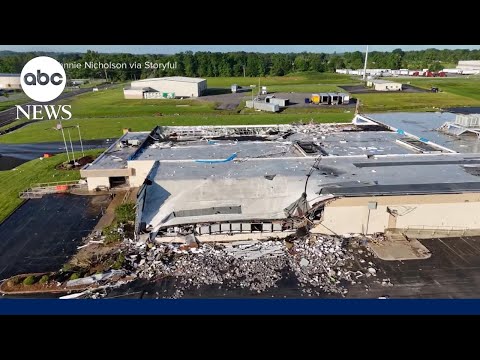
Bu kasırgaların neden olduğu hasarın tam ölçeğini kavramak muhtemelen çok zaman alacak. Ve burada Texas A&M Üniversitesi araştırmacılarının yardımcı olabileceğini düşünüyorlar.
Kasırga Sonrası Hasar Değerlendirmesindeki Zorluklar
Böyle bir olayın ardından acil müdahale ekipleri, şehir planlamacıları ve sigorta uzmanları yıkımı ve atılacak adımları değerlendirmek üzere bölgeye gider.
Kasırgalarda bu zorluk daha da belirgindir: Şiddetli rüzgâr ve savurduğu ağır cisimler, sağlam binalarda bile büyük hasara yol açabilir.
“Afet sonrası hasar araştırmaları genellikle zaman ve emek gerektirir; hızlı güncellemelerden çok modellerin ve yapı standartlarının sürekli iyileştirilmesine odaklanır.”
Afet sonrası hasarı değerlendirmek için mevcut verilerden yararlanan girişimler de var. Bunlardan biri, belirli bir konuma ilişkin çeşitli veri katmanlarını bir araya getiren coğrafi bilgi sistemleridir (CBS).

Bununla birlikte, mevcut verilerin kullanımı tek başına yeterince doğru değerlendirme sağlamayabilir. Verileri işe yarar ölçülere dönüştürmek için hâlâ çok sayıda insan müdahalesi ve uzman yorumu gerekir. Ek görüntü verileri ile yapay zekâ burada yardımcı olabilir.
Hasar Değerlendirmesi ve İyileşme için Yapay Zeka Destekli Model
Mevcut Kaynakları Yapay Zeka ile Birleştirme
The researchers combined 3 different tools together: remote sensing, deep learning, and restoration modeling.
Araştırmacılar, afetin hemen sonrasındaki hasarı ve değişimi değerlendirmek için yüksek çözünürlüklü uydu veya hava fotoğrafları gibi uzaktan algılama verilerini kullandı.
“Bu görüntüler, etkilenen bölgenin geniş ölçekli görünümünü sundukları ve büyük bir alandaki hasarın hızla tespit edilmesini sağladıkları için çok önemlidir.”
Abdullah Braik – Texas A&M’de inşaat mühendisliği doktora öğrencisi
Ardından derin öğrenme yöntemleri, görüntüleri otomatik olarak analiz edip hasarın derecesini belirlemek için kullanıldı.
Model, önceki afetlerden alınan binlerce görüntü üzerinde eğitildi. Çökmüş çatılar, eksik duvarlar ve dağılmış enkaz gibi görünür işaretleri tanıyarak binaları hasarsız, orta derecede hasarlı, ağır hasarlı veya yıkılmış gibi sınıflara ayırıyor.
Son bileşen iyileşme modellemesi. Bu aşamada altyapı özellikleri ile gelir düzeyi ve kaynaklara erişim gibi toplumsal etkenlere ilişkin veriler kullanılıyor.
Ayrıca mevcut iyileşme modelleri, farklı finansman veya politika koşullarında evlerin ve mahallelerin toparlanmasının ne kadar sürebileceğini tahmin etmek için kullanılıyor.
Yöntem, hasar değerlendirmesinin üç aşamasını bir araya getiriyor:
- Uzaktan algılama, tüm durumun anlık bir özetini sunar.
- Afet sonrası görüntüler elde edildikten sonra yapay zekâ modeli verileri bir saatten kısa sürede analiz edebilir; bu, kapsamlı saha incelemelerinden çok daha hızlıdır.
- İyileştirme modellemesi, yapay zeka değerlendirmesini hangi bölgelerin en çok yardıma ihtiyaç duyduğunu ve hangi kaynakların gerektiğini gösteren uygulanabilir metriklere dönüştürür.
“Bu araştırma, hızlı afet değerlendirmesi ile uzun vadeli stratejik iyileşme planlaması arasındaki boşluğu kapatarak kasırga sonrası dayanıklılığı artırmak için riskleri dikkate alan pratik bir çerçeve sunuyor.”
Abdullah Braik – Texas A&M’de inşaat mühendisliği doktora öğrencisi
Yapay Zeka Modelini Gerçek Dünya Kasırga Verileriyle Doğrulama
Araştırmacılar yöntemi sınamak için 2011’de Missouri eyaletinin Joplin kentini vuran kasırgaya ait verileri geriye dönük olarak inceledi.
Afet ayrıntılı biçimde belgelenmişti. Bu sayede modelin ürettiği hasar değerlendirmeleri, o dönemde sahada kaydedilen gerçek hasar bilgileriyle karşılaştırılabildi.
Modelin sonuçları tarihsel kayıtlarla yakından örtüştü. Hasar dağılımı, kasırganın izlediği yolun yeniden oluşturulmasına da yardımcı oldu.
“En ilginç bulgulardan biri, hasarı yüksek doğrulukla saptamanın yanı sıra kasırganın izlediği yolu da tahmin edebilmemizdi.
Hasar verilerini analiz ederek kasırganın yolunu yeniden oluşturduk; sonuç tarihsel kayıtlarla yakından örtüştü ve olayın kendisine ilişkin değerli bilgiler sundu.”
Abdullah Braik – Texas A&M’de inşaat mühendisliği doktora öğrencisi
Yapay Zeka Modelini Diğer Doğal Afetlere Ölçeklendirme
Yöntem kasırga hasarı için geliştirilip geriye dönük olarak sınandı. Uygun afet sonrası görüntüleri ve bu afetlere özgü eğitim verileri sağlanırsa, fırtına ve deprem gibi başka olaylara da uyarlanabilir; ancak bu kullanım alanları için ayrıca doğrulama gerekir.
Deprem hasarı, uçmuş bir çatı kadar kolay görünmeyebilir. Yine de yeterli örnekle eğitilmiş bir model, görüntülerde insan gözünün kolayca ayırt edemediği örüntüleri saptayabilir. Bu olasılık, her afet türünde aynı doğruluğun sağlanacağını göstermez.
“Modelin farklı afetlere uyarlanabilmesinin anahtarı, onu her tehlike türüne ait geçmiş görüntülerle eğitmek ve o olayın kendine özgü hasar örüntülerini öğrenmesini sağlamaktır.”
Abdullah Braik – Texas A&M’de inşaat mühendisliği doktora öğrencisi
Araştırmacıların ayrıca denediği bir diğer ABD afet türü, tropikal siklonlardır.
“Modeli kasırga verileri üzerinde de sınadık; sonuçlar, başka tehlike türlerine uyarlanabileceğine dair umut verici bir potansiyel gösterdi.”
Abdullah Braik – Texas A&M’de inşaat mühendisliği doktora öğrencisi
Bu çalışma, yapay zekânın afet alanındaki diğer uygulamalarıyla da bağlantılıdır. GraphCast, Spire ve Climavision gibi sistemler hava tahminlerinde yapay zekâdan yararlanıyor; hava tahmini ile afet sonrası bina hasarı değerlendirmesi farklı görevlerdir.
Araştırmanın gelecekteki bir uzantısı, ilk hasar değerlendirmesinin ötesine geçerek yeniden inşa sürecindeki ilerlemeyi zaman içinde güncellemek olabilir.
Bu tür otomatik geri bildirim, karar vericilerin kaynak dağılımını ve yeniden inşa çalışmalarını gözden geçirmesine yardımcı olabilir.
Uydu Verileri ve Yapay Zekaya Yatırım
Spire
SPIR Fiyat Grafiği
Spire, dünyanın en büyük çok amaçlı uydu takımyıldızını özel sektörde işleten bir uzay veri şirketidir.
Şirket hava durumu verilerine odaklanıyor. Uydu ağı atmosfer ve yeryüzü koşullarına ilişkin çeşitli ölçümler sağlayarak belirli bir bölge hakkında daha ayrıntılı veriler sunuyor.
Toprak nemine ilişkin uydu verileri yaklaşık 100 metrelik çözünürlükte sunuluyor. Çiftçiler, sigortacılar, emtia piyasası katılımcıları, çevre izleme kurumları ve inşaat mühendisleri bu verileri toprak koşullarını ve olası tarımsal verimi anlamak için kullanabilir.

Kaynak: Spire
Spire, LEMUR uydu platformuyla müşterilerine özel uydu takımyıldızları kurmayı da teklif ediyor.

Kaynak: Spire
Şirket, güvenlik ve havacılık alanlarında da çalışıyor. Havacılık hizmeti, uçakların konumu ve diğer uçuş bilgileri için GPS verilerinden yararlanan ADS-B sinyallerini izliyor.
Spire, ABD Uzay Kuvvetleri tarafından yeni nesil uzay deneyleri için küçük uydu platformlarını tasarlamak, üretmek, birleştirmek ve işletmek üzere 237 milyon dolarlık bir sözleşmeye seçildi.
Spire’ın uyduları denizcilik sektöründe gemi takibi için de kullanılıyordu; ancak şirketin bu birimi Nisan 2025’te Kpler tarafından satın alındı.
Yapay zekâ alanında Spire, NVIDIA (NVDA ) ile işbirliği yapıyor. Şirket, radyo örtülmesi (RO) ölçümlerini ve kendi veri özümseme (DA) verilerini NVIDIA Earth-2 Cloud API’lerine entegre etmeyi hedefliyor.
“Spire’ın kendi verileri ve küresel hava durumu kapsaması ile NVIDIA’nın teknolojik uzmanlığını birleştirmek, hava tahminlerinin doğruluğunu önemli ölçüde artırmamıza yardımcı olabilir. Bu işbirliği, müşterilerimizin değişen iklim koşullarına daha hazırlıklı yanıt vermesini amaçlıyor.”
Michael Eilts – Spire’da hava ve iklim genel müdürü
Spire; hava tahmini, tarımsal analiz, uçak takibi ve savunma gibi alanlarda uydu verileri ile yapay zekâyı birleştiren bir veri şirketi.
Şirket 2025’in ilk çeyreğinde yeni hisse satışından brüt 40 milyon dolar elde etti. Ölçeği büyüdükçe kârlılığa ulaşabilir; ancak gelecekte yeniden sermaye artırımı yapıp yapmayacağı ve yatırımcıların payının seyrelip seyrelmeyeceği belirsizdir.

Kaynak: Spire
En Son Spire (SPIR) Hisse Senedi Haberleri ve Gelişmeler
Çalışma Referans:
1. Abdullah M. Braikve Maria Koliou. Kasırga sonrası otomatik bina hasar değerlendirmesi ve iyileşme tahmini, uzaktan algılama, derin öğrenme ve iyileştirme modellerinin entegrasyonu. Sustainable Cities and Society. Cilt 123, 1 Nisan 2025, 106286. https://doi.org/10.1016/j.scs.2025.106286



