
Aerospace
Planet Labs (PL): The Scalable Business of Earth Imaging
Securities.io maintains rigorous editorial standards and may receive compensation from reviewed links. We are not a registered investment adviser and this is not investment advice. Please view our affiliate disclosure.
All Seeing Eyes: Why Earth Imaging Is Booming
The space and satellite industry is experiencing a revolution with companies like Rocket Lab or Intuitive Machines entering the market aggressively. This does not mean that established players in this space are not still important and able to keep up.
Traditionally, non-military space businesses have been centered on satellites for both telecommunications and Earth observation.
The ability to observe Earth from space has only improved in the past decades, as electronic and optical components became more advanced, allowing for an increasingly detailed and complex view of the Earth’s surface.
Another improvement brought to the satellite industry is the quickly declining cost of launch to orbit, and increasingly larger launchers. As a result, more powerful, more complex satellites can be launched today that would have been utterly impossible even just 5 years ago.
At the same time, Earth observation is a service that needs to be delivered in an easy-to-use form, as most of the users will not necessarily be space specialists, but farmers, construction companies, government employees, etc.
This creates a market for companies able to both produce high-quality images of Earth and deliver them in a price-effective package to their end users. One leader of this business is the company Planet Labs.
Planet Labs PBC (PL +25.48%)
Planet Labs Overview
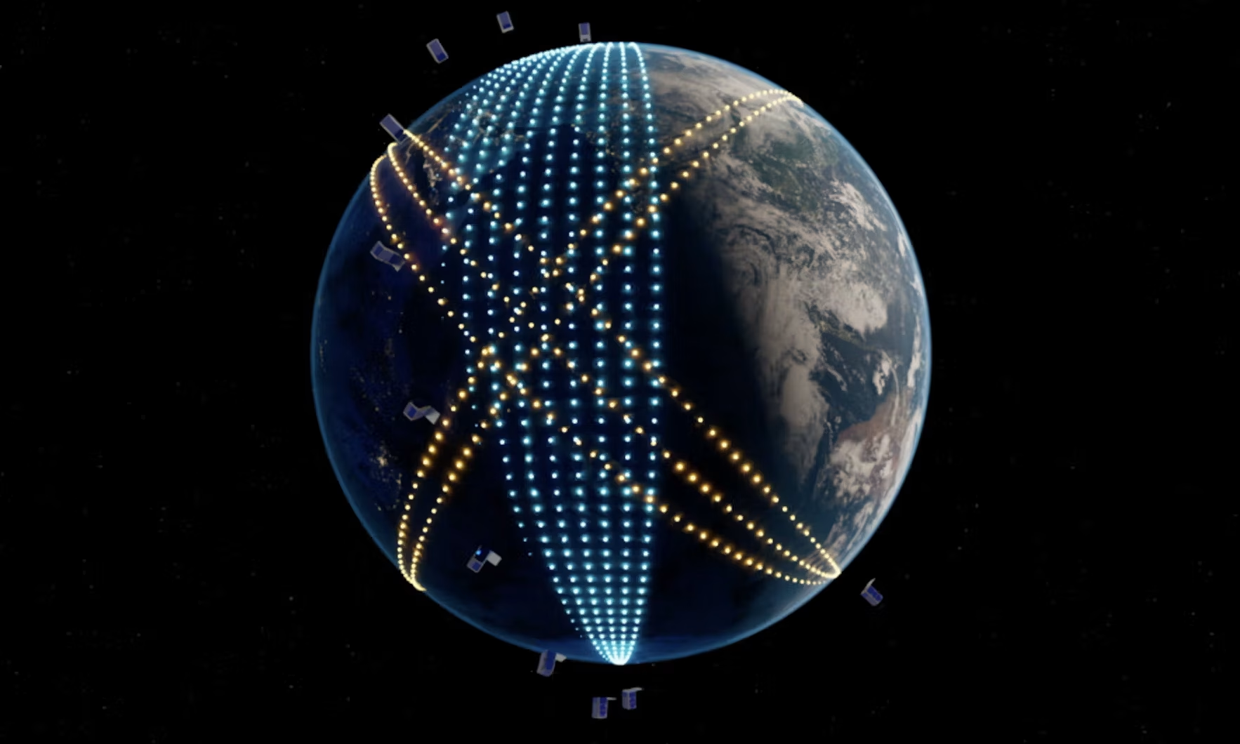
Planet Labs owns a fleet of approximately 200 Earth imaging satellites, the largest in history, imaging the whole Earth’s land mass daily.
It was founded in 2010 and grew through a series of acquisitions and several new satellite constellation launches. The company’s stock was publicly listed in 2021. The company operates a total of 5 different satellite constellations, each with a specialty of its own.

Source: Planet Labs
- PlanetScope: A constellation using small CubeSats, measuring 10 cm × 10 cm × 30 cm in a relatively low orbit (525 kilometers altitude – 326 miles).
- Each of the satellites is focused on one type of sensor, and the synthetic image of the whole constellation can be used to create a high-definition image of a large segment of Earth.
- Tanager: A constellation using best-in-class hyperspectral imaging satellites to detect methane emission with 3-6x more sensitivity than comparable space-borne systems, with a 30m resolution.
- Pelican: A next-generation constellation targeting 30–50 cm resolution imagery across visible and near-infrared bands.
- SkySat: A constellation able to focus on demand on specific spots of the planet, with a 50cm per pixel resolution, which can capture video clips up to 90 seconds long at 30 frames per second.
- Owl: A planned 40-satellite constellation focused on surveillance, targeting near-daily 1-meter imagery when fully deployed. The first launch is currently projected for late 2026.
Together, these constellations allow Planet Labs to have ready on hand the right type of satellite for any observation job one of its clients could need. This also means that the company’s customers can first identify an element of interest with one constellation, before digging deeper with another one.
Beyond Just Pictures: Hyperspectral & Analytics
Images generated by Planet Labs’ satellites are not just high-resolution; they also include hyperspectral data (visible + infrared and UV light). As a result, they can be used not just to look at the land, but also to analyze it further.
For example, the image can determine the moisture content of the soil, methane emissions, or underwater activity.

Source: Planet Labs
A large database of observations over a long period of time can also give extra information. For example, government and military institutions can observe construction projects made in other countries. A geologist and a construction company can assess the stability of a mountainside before starting a major infrastructure project.
The regular production of new images also guarantees that any change will be detectable and possible to analyze very quickly.
What makes Planet unique for us is the revisit rate with PlanetScope … when an event has happened, often with no warning, we know that that data has been captured.
Louise Jones – Head of Intelligence at McKenzie Intelligence Services
Applications
Overall, the potential applications of Planet Labs satellite imagery are very wide and address many sectors, with the same satellites used for varying purposes.
Agriculture
The revisit of the same site daily by Planet Labs’ dense constellation of satellites allows for constant monitoring of fields and farms. This provides valuable input at each stage of crop management.
For example, this data can be used to determine optimal seeding practice, where irrigation is needed, what nutrient is missing for a given crop or segment of a field, etc.
It can also detect the spread of diseases or pests, and optimize the use of treatment to mitigate them.
The company also has a strong archive, with 1,300 images in storage for every acre on Earth. These images can also be integrated into the same software with on-site data, like soil samples or in-person observations.

Source: Planet Labs
The synthesis of all this data and the history of past years can create a very precise estimate of future harvests and crop yields, while optimizing best practices.
Forestry
Satellites are today powerful enough to not only help with mapping and planning timber harvest, but also to estimate the standing timber inventory and the capacity over different areas. Archival data can even evaluate past growth rate and the maturity of the forest.
There is no other comparable commercial system offering the combination of sensing large areas in high spatial and temporal resolution.
Petr Lukeš – Remote Sensing Specialist, Czech Republic Forest Management Institute (UHUL)
Another forestry application is the quick assessment of disasters’ impact, like wildfires or floods. The spread of tree-killing diseases or pests can also be assessed from space, both by the forestry company and the relevant governmental organization.
Lastly, satellites can help identify illegal logging in remote areas, for example, deforestation in the Amazon rainforest or Indonesia.
Planet imagery may be used to detect and map deforestation events greater than one hectare. Results show that the change caused by deforestation can be automatically extracted with high accuracy.
Infrastructures
A clear, holistic view of the situation is often difficult to acquire for large infrastructure projects that might be relying on sub-optimal on-site analysis or operate in remote regions.
Planet Labs satellites can help alleviate a lot of issues for infrastructure construction and management:
- Remote satellite visualization of damage, degradation, and corrosion.
- Analyze proposed sites for future infrastructure projects, plan the construction, oversee project development, and anticipate delays.
- Detect encroachment and monitor right of way.
- Map environmental impact.
Science Programs & Sustainability
Scientific analysis is built on accurate data. And unfortunately, most science programs will deal with a very limited budget and manpower for field trips, on-site analysis, and other data-collecting activities.
As a result, more than 20,000 scientists globally, in 100+ countries, can rely on Planet Labs images to alleviate this issue, with more than 2,000 scientific publications having used the company’s images.

Source: Planet Labs
Many scientific programs can get access to Planet Labs images through sponsorship programs organized by NASA, the ESA (European Space Agency), and other international research organizations.
Planet Labs data can also be used to monitor many sustainability metrics, from sustainable forestry to methane emissions, biodiversity, and carbon absorption.

Source: Planet Labs
Defense & Intelligence
Military and intelligence agencies have, of course, their own secret program of spy satellites. But either because these systems cannot observe everything at once, or to better keep some of their capacities hidden, they also use a lot of commercial providers that can provide a more consistent and omnipresent coverage of the Earth.
Planet Labs’ Global Monitoring Service can detect change in near real-time, accelerate response time, and integrate multiple data sources to achieve global situational awareness.
For example, it could monitor nuclear silo construction in China.
A sea-focused solution, Maritime Domain Awareness monitors ports, waterways, and strategic open water areas, leveraging an extensive archive with proprietary datasets dating back to 2009.

Source: Planet Labs
The same monitoring can be used for economic analysis, with the measurement of port activity, ship traffic, etc.
Planet’s proven ability to provide immediate answers to critical questions concerning enemy force dispositions, actions, and intentions gave [our] forces an exploitable advantage over the enemy.”
U.S. Military Official
Insurance
Data about drought, disasters, and infrastructures are all extremely precious to insurance companies. By using Planet Labs images, an insurance company can accurately predict risks, payments, and future costs of its insurance contracts.
Planet Labs even offers insurance companies automated change detection and alerts, and the possibility of 5-7x revisit per day (the highest frequency commercially available) for real-time monitoring.
Transparent Pricing & Scalable Business Model
The company offers transparent pricing, with different subscriptions depending on the regions of the world covered and the number of square kilometers of surface demanded.
This creates a possibility for companies to start using Planet Labs’ data and slowly increase their data consumption as they integrate satellite images into their work process.

Source: Planet Labs
90% of revenue is recurring and from annual or multi-year contracts, creating extremely predictable cash flows for Planet Labs.
Because the costs of the satellite constellations are mostly upfront, this makes the business model inherently scalable. Any additional client cost is very little to Planet Labs, and helps amortize the satellite costs among more subscriptions.
Swipe to scroll →
| Company | Primary Strength | Resolution | Revisit Rate | Key Customers |
|---|---|---|---|---|
| Planet Labs | Daily global coverage, hyperspectral data | 30–50 cm (Pelican) | Daily (up to 5–7x in tasking mode) | Defense, agriculture, insurance |
| Maxar | Ultra-high resolution imaging | 30 cm | Daily to every few days | Defense, governments |
| BlackSky | High revisit for real-time alerts | ~1 m | Up to 15 revisits/day | Defense, security |
| Satellogic | Low-cost imaging at scale | 70 cm | Weekly | Agriculture, mapping |
Planet Labs Financials: Revenue, Segments & Profitability
Planet Labs recorded $245M in revenues in the 2025 fiscal year, doubled from only $122M in 2022, with record revenues in Q2 2026 ($73M).
The largest source of revenues is the North American region (45%), and defense and intelligence represent more than half of the revenues.

Source: Planet Labs
AI & Geospatial Analytics: Turning Images Into Insights
AI training and utilization require as much high-quality data as possible. With its backlog of satellite images, Planet Labs is the perfect provider of an AI training data set for the prediction of the effect of climate change, natural catastrophes, or more mundane predictors of cost overrun of infrastructure projects.

Source: Planet Labs
AI can also be used to make the images more useful, increasing the value of Planet Labs satellites. For example, roads can be automatically added to digital maps as soon as they are made.

Source: Planet Labs
Planet Labs Growth Outlook
As a trusted provider of data, Planet Labs could benefit from a few trends, irrespective of where the space industry goes:
- It can license out or use its images to train AIs, both for better real-time monitoring and novel insights.
- It will benefit from the price war between launch providers like SpaceX and Rocket Labs, making the maintenance and replacement of its satellite fleet cheaper.
- It will benefit from the economies of scale in satellite manufacturing, making new, more capable models cheaper, as it demonstrated with the recent addition of hyperspectral data to its offerings.
Is Planet Labs (PL) a Good Investment?
For a company using very advanced technology, Planet Labs is a remarkably easy-to-understand business.
It built the world’s best constellations of observation satellites, constantly collecting high-quality images of the globe. It then sells these images to anyone who can benefit from using them, be it farmers, builders, or government agencies.
The better the images, and the more digitalized other systems get, the more valuable these images become.
Due to the massive backlog and experience of the company, it has a solid business moat compared to eventual newcomers. This also makes it a key partner for anyone looking to use such satellite images to train AI or to use for AI-related applications.
Now that the company is cash flow positive, it has firmly entered the growth stage, where scale means more profits with relatively little additional expenditure.
Latest Planet Labs (PL) Stock News and Developments
Planet Labs PBC (PL) Q4 2026 Earnings Call Transcript
seekingalpha.com
•
March 21, 2026
Stock Traders Buy Large Volume of Call Options on Planet Labs PBC (NYSE:PL)
defenseworld.net
•
March 21, 2026
Planet Labs PBC (NYSE:PL) Reaches New 12-Month High on Analyst Upgrade
defenseworld.net
•
March 21, 2026
Planet Labs Crushes Earnings, But Risk Is Rising
seekingalpha.com
•
March 20, 2026
Why Planet Labs Stock Popped Today
fool.com
•
March 20, 2026
Stock Market Today, March 20: Planet Labs Surges After Record Revenue and Upbeat Guidance
fool.com
•
March 20, 2026


